Showing posts with label Walks. Show all posts

Saturday, September 27, 2008

Orford - Castle and Ness

For a change this is a post about somewhere in Suffolk on my Suffolk Blog.

Last weekend we took advantage of the great weather that's finally arrived and went for a day out to Orford. Here we were able to use our memberships in both the National Trust and English Heritage all in one day.


First was a trip over to Orford Ness on the National Trust ferry. The trip costs just £3.70 for members, and you can spend as long as you like on the Ness, subject to catching the last ferry back at 5:00pm.

There are trails to follow around, which must be kept to. A lot of aircraft testing of bomb trajectories was carried out on Orford Ness, and so there is a danger of unexploded ordinance still to be found.

We started out by going to the displays about the history of the area which is inside one of the old military buildings.

From there the trail continued on to reach the lighthouse, which is one of the major features.


After stopping on the beach for a picnic lunch, we walked back across the expanse of shingle to head to some more of the buildings. Though as you can see, it's difficult to get away from that lighthouse with the ground being so flat!


Next point on our tour was the Black Beacon, which was built to house an experimental navigation beacon in 1928. Now it is open as a great viewing platform through small slotted windows. Each window has a picture above it to label what can be seen in that direction.


The second trail we followed took us out towards the tall masts which broadcast the BBC World Service radio. This section of the ness contains lots of grazing marshes, and channels of fresh water. We saw plenty of gulls around, plus some little egrets and wheatears.


After catching the boat back to Orford we called in for a cup of tea at the Riverside Tearoom, then walked back up through the town to the castle. Here our English Heritage cards got us in for free and we collected our audio tours to lead us around.

The tour gradually led us up the levels of the castle, ending up on the rooftop. From here we could see all over the town and back across to the lighthouse.

Unfortunately we had to rush the tour a little, as it lasts for almost an hour, and we had just 50 minutes until the castle closed. We skipped the introduction, and also the basement section.


Back outside we had a brief walk around the ridges of the castle defenses, getting the whole building in a picture by using a wideangle lens which has made an unusually bent castle.


The castle really shone in the evening light, looking quite golden.

We ended the day by going for tea in the Kings Head pub.

Wednesday, April 09, 2008

Pembrokeshire Coast Path

It's taken a lot longer than expected to get a blog written up about walking the Pembrokeshire Coast Path in July last year, but finally it's finished and publicly available! It's in a similar style to the Lake District one, with photos to show what each day was like.

Also there's a list of places to stay, useful even if you're not walking the whole coast path but are just looking for a B&B in Pembrokeshire.

The new blog is at pembrokeshirecoastpath.blogspot.com so please have a read and enjoy the sea air.

Friday, February 08, 2008

Caching around home

At last some good weather. We decided it was time to get out for a decent walk as we hadn't done much distance this year so far. To pick somewhere to go we looked for the nearest geocach to home, which turned out to be in the village of Gedding.

The route from Hitcham to Gedding is the way I drive in to work each day along nice quiet lanes, so we stuck to the roads to get there. It made quite a difference being on foot, seeing so much more of the surroundings. Of course it took a lot longer too! A little under 2 hours, compared to the normal 10 minutes.

Once in to Gedding the GPS led us to a little church, which I have never been past before. The cache was hidden just a short distance behind the church on a footpath. It was easily found, and we dropped off one of our 'calling cards'.


The church is very decorative, with flint inlaid in patterns. Looking from the churchyard you can also see Bill Wyman's house.


We left Gedding, and then took followed footpaths to get to Bradfield Woods. Here we stopped for lunch, a flask of soup. It was freezing though, so didn't sit for long. We then decided to continue on footpaths to take a different route home. This way we also spotted a few deer in the fields, and also saw a bird with a long beak which we think must have been a Woodcock.

Total distance in the end was just over 13 miles which felt like a good bit of exercise.

Tuesday, October 09, 2007

Geocaching Monday

As the weather was reasonable and we had spent the weekend indoors completing our Inn Way report (yes it's finished! - click here to read all 9 days and recommended B&B's in the Lake District) we decided to get outside and find a few geocaches.

Looking on the website there were a few new caches set up that we hadn't been too, and we could also combine visiting them with checking up on some caches that a friend of mine owns.

First we headed to Ixworth Thorpe and had a short walk along a farm track and through some woods to get to the site. This seemed a popular path with runners, several times we were passed as we hunted for the cache container just off the footpath. Eventually I found it and we filled in the log book.

Next stop was Ampton Water where we did our first check on my friend's cache. It was still well hidden and the container was full of things to swap.

Back in the car and over to Coney Weston for the next new find. The cache was called 'Gnome Sweet Gnome' and we soon found why :


The cacher who set this one up likes creating unusual hiding places. Another later in the day wasn't anywhere near so obvious as a bright red door in a tree! Again the name contained a clue - 'Not Mush Room' - therewas only space in the 'container' for a slip of paper to sign.

We then enjoyed a good walk around Knettishall Heath, performing another maintenance check there. This cache hasn't been found for 6 months as it requires some work to find out where it is hidden.

Finally we dashed over to Brandon Country Park and had a very quick walk around a route there to check on the third of my friend's caches. The log book in this one was full as it's a very popular spot, so we put in a new one.

According to the GPS we totalled up a little over 7 miles in all of our short walks, so not bad for an afternoon.

Tuesday, October 02, 2007

Further progress

More days have now been added to my Lake District Inn Way report, including the amazing photographs of Buttermere.

I've booked to go away to the Lakes for Christmas this year, so hope to get lots more photographs then too.

Thursday, September 27, 2007

A second blog

Once again I haven't written anything here for a few weeks. The Inn Way walk in the Lake District went ahead as planned earlier this month. 9 days of walking, just about 100 miles, went into 43 pubs and sampled 55 different ales!

That's not quite as bad as it sounds - I wasn't staggering around the fells in a drunken stupor. Each drink was only a half, and then that was shared between the two of us which brings it down to a much more reasonable sounding 1.5 pints per day.

I have starting writing up each day's walk with details of distance, pubs, scenery and accomodation, including lots of photographs. I've done this as a separate blog which is now available to view. Vist my Lake District Inn Way blog page.

The first three days are there, with the fourth due to be ready tonight. Hope you have a read and enjoy it.

[Update - day 4 is now complete. Day 5 to follow with some amazing photos of Buttermere]

Friday, June 29, 2007

Holiday Time Again!

Yay - it's Friday, it's 5:30 and it's time to finish for a two week holiday!

Pembrokeshire Coast Path here I come. Well, just need to pack tonight and then navigate over to Wales tomorrow whilst avoiding any floods. Then it's a few days in a cottage to relax before starting the walk proper on Wednesday next week. 185 miles, 12 bed and breakfasts (so 12 full cooked breakfasts!) and I'm sure a there'll be a few pubs along the way.

Oh and there's about 35 geocaches on the route too which I'll try and find.

Photographs as usual when I get back.

Thursday, June 28, 2007

The Angles Way (day 2)

Sunday turned out to be not such a good day as the Saturday had been. This was both in terms of weather and also the walk itself.

After a good nights sleep (being woken once by ducks drinking water of the tent that had collected overnight!) we got the tent packed away just as it started to rain. The rain lasted for most of the day, never really heavy but never light enough to take off waterproofs so it was quite hot and sticky going.

From Scole to Harleston the path seems to wind backwards and forwards at random. We crossed the main A143 several times. Approaching Brockdish it suddenly doubles back and takes you about 3/4 mile detour to end up a few hundred yards further on down the same road. Then you are taken back over the A143 once again to pass through an industrial estate and new housing developments at Harleston. I'm sure there must be some nice part to the town, but we never got to see it.

Today wasn't really a day for photographs, but we did take one of a bull as we passed by his field. Not sure that the fence would really prove much of a deterrant to him if he wanted to get out!


Things did improve a little after Harleston. Then we decided to cut our walk short as we had to be in Bungay by 6pm that evening for a meal. As we came down to Mendham we spotted R's parents in their car who were supposed to be meeting up with us a few miles further on. Just by coincidence they had stopped to check the map and then saw us coming down over the fields and waited. They had tried walking some of the path further along near Earsham and found an electric fence right across it with no clear sign where the path went. Given this we agreed that the 13 miles that we had done already were enough for the day and drove to meet up with the rest of the family and get cleaned up ready for going out.

The rest of the evening was lovely, the Thai Kitchen in Bungay is highly recommended if you are ever looking for somewhere to eat.

The Angles Way

The weather really did seem to be on our side for the walk and camping. On Saturday we had maybe 10 minutes of rain while walking. For most of the day we could just go along in t-shirts. Lots of storms around nearby though so I'm sure many people weren't so lucky.

The Angles Way proved to be quite a mixed sort of path. The start from Knettishall Heath was lovely, as was walking through the many fens in the area. Who knew there could be so many Fen Lanes, Fen Streets, Fen Roads all in a small area! We detoured slightly around Redgrave and Lopham Fen to find a geocache there. While there we passed a great nest box - just hope that birds can read.


Other views...

(I wonder who styles this cow's hair?)


Shortly before reaching Diss the path seemed to change from a well used way into a random collection of footpaths. At one point it heads straight through a field currently 6 ft high with oilseed rape.


A path had been cut through earlier in the year as the crop was growing, but with the plants either side being so tall they had just collapsed in. Thankfully it hadn't rained there so they were dry to push through.

Finally at 7pm we arrived at our campsite in Scole - 8.5 hours and 19 miles from Knettishall Heath. It's a nice quiet site, with the River Waveney running through it. We last camped there 12 years ago when cycling, and not much had changed. It was still inhabited by lots of friendly ducks. Immediately after setting up the tent we got our first real downpour complete with thunder. Great timing! It only lasted for 15 minutes or so then we could get on with cooking tea.

Friday, June 22, 2007

Must be mad!

Despite the forecasts predicting so much rain and thunder and lightning over the weekend, I'm still seriously planning to go walking and camping tomorrow along the Angles Way.


Starting off at Knettishall Heath, the path follows the Little Ouse river to it's source at which point it looks like it then starts flowing in the opposite direction to become the River Waveney. If all goes well I should be camping in Scole tomorrow evening, then heading on to Bungay on Sunday.

Then in Bungay the plan is to meet up with family for a meal out to celebrate my niece's 9th birthday. Is walking gear and rucksack (potentially dripping wet) considered suitable attire for a restaurant?

Thursday, May 10, 2007

A long weekend in the Langdales

One bonus of my working 4 day weeks is that when a Bank Holiday Monday arrives, I get the Tuesday off in place of it. So last weekend I also booked off the Friday before and got 5 days away for 1 day of holiday.

We went camping in the Lake District, staying at the National Trust campsite at Great Langdale.


Getting there took us 5 and a half hours, and we set off at 5 in the morning! You can't book a pitch at the site, so it's first come first served. By getting there early on Friday we felt we had a better chance of getting on, and this proved to be true. They expected that by the afternoon they would be full.

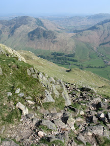
After pitching the tent (spending ages hammering in pegs that seemed to know just where the stones / tree roots were) we went out for our first walk. This was up to Stickle Tarn, then around over Harrison Stickle. From up here we could look down on the site, and see it filling up.


(Campsite is in the trees in the middle of the picture)

Mountains are something we are sorely lacking in Suffolk. Walking in the Lakes is a completely different experience. We were puffed out after just a couple of miles, though to be fair we had climbed up 2000 feet.

Saturday was a great day to walk, there was a little cloud on the tops of the hills, but it was warm and forecast to stay dry. We did a long day, walking from the campsite up to the top of Bowfell (2960ft), along to Esk Pike (2903ft), then onwards to the highest point in England, Scafell Pike (3210ft).


(Bowfell Summit)

Back at the campsite that evening we watched a mountain rescue team assisting an injured walker on the hillside above the campsite. Someone had been struck by falling rock, and had to be lifted off by helicopter.

Sunday's walk started out as a plan to go up Pike o Blisco, but as we climbed the wind and rain got up. Abandoning that idea, we went on a circular walk around the hill, getting thoroughly soaked in the process. Fortunately the campsite had a tumble drier available, so all our gear went into that when we got back.

By Monday morning the campsite was getting much emptier - many people left on Sunday night either to beat the Bank Holiday traffic, or just giving up due to the weather. We set out on a lower level walk for the day, which of course then turned out to be fine and dry. We did manage to get to the top of another Wainwright fell - Loughrigg. From there we had great views down Lake Windermere, back up the Langdale valley and also over to Conniston. We then dropped down into Grasmere and picked up a bottle of wine to have with our camp stove cooked meal that night.

After finishing that up we settled in to the tent, then didn't get much of a restful night due to gales and downpours. The next morning we did a full cooked breakfast in the rain! By 11am there was no sign of it stopping so we had to pack the tent up wet. By the time we left, some of the streams around the site were looking rather full so we didn't mind too much that we had to go.


The view from our tent after everyone had gone home

Thursday, May 03, 2007

Waking up outdoors

Last weekend R and I completed our Sandlings Walk camping trip. Starting from Ipswich on Saturday morning, we made it all the way up to Southwold at 7pm on Monday.

We made a strange site walking across Rushmere golf course just before 9am on Saturday. Two people with large backpacks on mustn't be all that common on the fairways! Not too long later and we had left behind the built up areas and made it on to Martlesham Heath. The path then follows up the River Deben into Woodbridge. By this point it was a little after 11 and we were ready for a break. The smell of bacon from the riverside cafe was too tempting so we stopped for some mugs of tea and a bacon sandwich. Refreshed from that we continued on passing through the village of Bromeswell then down on to Sutton Common. Eventually we got into Tangham forest and set up camp at the forestry site. First days mileage - 17.5 so we were ready for the showers, food and bed.

Sunday morning was then a great feeling. It's so nice to wake up, open the tent door and just be outdoors. We boiled up the kettle and had tea, followed by bowls of porridge. We packed up and were on our way again just after 9. Starting right from the middle of the forest meant that it was really quiet. We saw plenty of birds and also a few deer. We also passed by the campsite that wouldn't allow us to book. He had just 2 caravans on the site so we couldn't understand why they wouldn't accept us for Saturday night. Still it would have meant walking an extra 4 miles the day before so we didn't mind.

It was a different story towards the end of the day of course - we then had the extra 4 miles to do! So Sunday turned into a 22 mile day. Highlights for the day included Wantisden church in the middle of nowhere, lunch at Snape Maltings and a weel earned pint of Adnams at our campsite near Sizewell at the end of the day. The biggest disappointment was planning on stopping off for a mid walk drink at the pub in Friston, but finding it closed when we got there.

The final day was 19 miles to Southwold, passing through Minsmere and Dunwich. From the very start point on the beach at Sizewell we could see Southwold lighthouse along the coast, but our route would be more winding inland. Dunwich forest was lovely. We've always walked along the coast before, this was the first time we had been on the inland route. I highly recommend a visit there. At long last Southwold came into sight again. We crossed the old railway bridge from Walberswick side and walked along past the fishing huts down to Southwold harbour. We finished just below Gun Hill, finding the final sculpture of the 11 that were placed along the trail.

Pictures to follow once I get them off the camera

Wednesday, April 18, 2007

I love Mondays

On Monday this week R and I headed over to Felixstowe for a day of walking and geocaching. We parked up on the seafront got on our boots and headed off through town. The first mile and a half was along the road until we were across the A14, almost into Trimley. From there we turned down a footpath and followed it to Searson's Farm, the starting point for the first cache of the day.

The picture on the left was taken just by the final cache location - a lovely quiet spot.

From here we continued on to the banks of the Orwell, where the next cache was located. From here we sat overlooking Levington marina. Lots of boats sailing up and down the river today too.

After this we re-traced our steps back inland, emerging at the far side of Trimley. We had last walked here a couple of years ago. There's a footpath hidden right alongside the A14 in a narrow strip of woodland. This is part of the Suffolk Coast and Heaths path.

Next stop was Falkenham church which was the starting point for cache number 3. By using dates and ages from some of the stones we put together the coordinates for the final location. Before setting off we found a very conveniently placed bench to sit and have dinner. Fully refreshed we made our way down to the banks of the Deben - also packed with people enjoying sailing in the sun.

We looked over to Ransholt and the pub there. We could have done with a boat ourselves to head over for a quick drink, but instead turned along the river to head back towards Felixstowe. Once we reached Felistowe Ferry it began to get busier. Plenty of people playing golf on the course there. The final couple of miles were along the sea-front past loads of beach huts. Several were in use today.

In total we walked 16 miles and found 5 geocaches. A good practice for the Pembrokeshire Coast path, although our coastline here doesn't have quite so much up and down.