Showing posts with label Suffolk. Show all posts

Saturday, September 27, 2008

Orford - Castle and Ness

For a change this is a post about somewhere in Suffolk on my Suffolk Blog.

Last weekend we took advantage of the great weather that's finally arrived and went for a day out to Orford. Here we were able to use our memberships in both the National Trust and English Heritage all in one day.


First was a trip over to Orford Ness on the National Trust ferry. The trip costs just £3.70 for members, and you can spend as long as you like on the Ness, subject to catching the last ferry back at 5:00pm.

There are trails to follow around, which must be kept to. A lot of aircraft testing of bomb trajectories was carried out on Orford Ness, and so there is a danger of unexploded ordinance still to be found.

We started out by going to the displays about the history of the area which is inside one of the old military buildings.

From there the trail continued on to reach the lighthouse, which is one of the major features.


After stopping on the beach for a picnic lunch, we walked back across the expanse of shingle to head to some more of the buildings. Though as you can see, it's difficult to get away from that lighthouse with the ground being so flat!


Next point on our tour was the Black Beacon, which was built to house an experimental navigation beacon in 1928. Now it is open as a great viewing platform through small slotted windows. Each window has a picture above it to label what can be seen in that direction.


The second trail we followed took us out towards the tall masts which broadcast the BBC World Service radio. This section of the ness contains lots of grazing marshes, and channels of fresh water. We saw plenty of gulls around, plus some little egrets and wheatears.


After catching the boat back to Orford we called in for a cup of tea at the Riverside Tearoom, then walked back up through the town to the castle. Here our English Heritage cards got us in for free and we collected our audio tours to lead us around.

The tour gradually led us up the levels of the castle, ending up on the rooftop. From here we could see all over the town and back across to the lighthouse.

Unfortunately we had to rush the tour a little, as it lasts for almost an hour, and we had just 50 minutes until the castle closed. We skipped the introduction, and also the basement section.


Back outside we had a brief walk around the ridges of the castle defenses, getting the whole building in a picture by using a wideangle lens which has made an unusually bent castle.


The castle really shone in the evening light, looking quite golden.

We ended the day by going for tea in the Kings Head pub.

Thursday, August 14, 2008

Geocachers Galleries

In our geocache "Meadows Meander", which is hidden in Ufford, we placed some disposable cameras so that the people who found it could take their picture.

The cache has now been in place for three years, and so far two cameras have been filled. Last night I finally got around to scanning in all of the pictures and uploading them to a web gallery. So if you've always wondered what sort of people would use multi-million dollar satellites to locate tupperware containers then have a look here and here.

Maybe someone you know will turn out to be a geocacher!

Friday, April 11, 2008

Feeding Time

We have some new visitors to our garden this week...


Friday, February 08, 2008

Caching around home

At last some good weather. We decided it was time to get out for a decent walk as we hadn't done much distance this year so far. To pick somewhere to go we looked for the nearest geocach to home, which turned out to be in the village of Gedding.

The route from Hitcham to Gedding is the way I drive in to work each day along nice quiet lanes, so we stuck to the roads to get there. It made quite a difference being on foot, seeing so much more of the surroundings. Of course it took a lot longer too! A little under 2 hours, compared to the normal 10 minutes.

Once in to Gedding the GPS led us to a little church, which I have never been past before. The cache was hidden just a short distance behind the church on a footpath. It was easily found, and we dropped off one of our 'calling cards'.


The church is very decorative, with flint inlaid in patterns. Looking from the churchyard you can also see Bill Wyman's house.


We left Gedding, and then took followed footpaths to get to Bradfield Woods. Here we stopped for lunch, a flask of soup. It was freezing though, so didn't sit for long. We then decided to continue on footpaths to take a different route home. This way we also spotted a few deer in the fields, and also saw a bird with a long beak which we think must have been a Woodcock.

Total distance in the end was just over 13 miles which felt like a good bit of exercise.

Tuesday, October 09, 2007

Geocaching Monday

As the weather was reasonable and we had spent the weekend indoors completing our Inn Way report (yes it's finished! - click here to read all 9 days and recommended B&B's in the Lake District) we decided to get outside and find a few geocaches.

Looking on the website there were a few new caches set up that we hadn't been too, and we could also combine visiting them with checking up on some caches that a friend of mine owns.

First we headed to Ixworth Thorpe and had a short walk along a farm track and through some woods to get to the site. This seemed a popular path with runners, several times we were passed as we hunted for the cache container just off the footpath. Eventually I found it and we filled in the log book.

Next stop was Ampton Water where we did our first check on my friend's cache. It was still well hidden and the container was full of things to swap.

Back in the car and over to Coney Weston for the next new find. The cache was called 'Gnome Sweet Gnome' and we soon found why :


The cacher who set this one up likes creating unusual hiding places. Another later in the day wasn't anywhere near so obvious as a bright red door in a tree! Again the name contained a clue - 'Not Mush Room' - therewas only space in the 'container' for a slip of paper to sign.

We then enjoyed a good walk around Knettishall Heath, performing another maintenance check there. This cache hasn't been found for 6 months as it requires some work to find out where it is hidden.

Finally we dashed over to Brandon Country Park and had a very quick walk around a route there to check on the third of my friend's caches. The log book in this one was full as it's a very popular spot, so we put in a new one.

According to the GPS we totalled up a little over 7 miles in all of our short walks, so not bad for an afternoon.

Thursday, June 28, 2007

Sunset from Hitcham

A few quickly grabbed photographs from the end of our garden last night as the sun suddenly dipped below the cloud and set.


Even a patch of nettles can look pretty in this light.


The final one, to the right there's a glider about to turn and land at nearby Rattlesden gliding club (you need to click and see the bigger image to make out anything!).

The Angles Way (day 2)

Sunday turned out to be not such a good day as the Saturday had been. This was both in terms of weather and also the walk itself.

After a good nights sleep (being woken once by ducks drinking water of the tent that had collected overnight!) we got the tent packed away just as it started to rain. The rain lasted for most of the day, never really heavy but never light enough to take off waterproofs so it was quite hot and sticky going.

From Scole to Harleston the path seems to wind backwards and forwards at random. We crossed the main A143 several times. Approaching Brockdish it suddenly doubles back and takes you about 3/4 mile detour to end up a few hundred yards further on down the same road. Then you are taken back over the A143 once again to pass through an industrial estate and new housing developments at Harleston. I'm sure there must be some nice part to the town, but we never got to see it.

Today wasn't really a day for photographs, but we did take one of a bull as we passed by his field. Not sure that the fence would really prove much of a deterrant to him if he wanted to get out!


Things did improve a little after Harleston. Then we decided to cut our walk short as we had to be in Bungay by 6pm that evening for a meal. As we came down to Mendham we spotted R's parents in their car who were supposed to be meeting up with us a few miles further on. Just by coincidence they had stopped to check the map and then saw us coming down over the fields and waited. They had tried walking some of the path further along near Earsham and found an electric fence right across it with no clear sign where the path went. Given this we agreed that the 13 miles that we had done already were enough for the day and drove to meet up with the rest of the family and get cleaned up ready for going out.

The rest of the evening was lovely, the Thai Kitchen in Bungay is highly recommended if you are ever looking for somewhere to eat.

The Angles Way

The weather really did seem to be on our side for the walk and camping. On Saturday we had maybe 10 minutes of rain while walking. For most of the day we could just go along in t-shirts. Lots of storms around nearby though so I'm sure many people weren't so lucky.

The Angles Way proved to be quite a mixed sort of path. The start from Knettishall Heath was lovely, as was walking through the many fens in the area. Who knew there could be so many Fen Lanes, Fen Streets, Fen Roads all in a small area! We detoured slightly around Redgrave and Lopham Fen to find a geocache there. While there we passed a great nest box - just hope that birds can read.


Other views...

(I wonder who styles this cow's hair?)


Shortly before reaching Diss the path seemed to change from a well used way into a random collection of footpaths. At one point it heads straight through a field currently 6 ft high with oilseed rape.


A path had been cut through earlier in the year as the crop was growing, but with the plants either side being so tall they had just collapsed in. Thankfully it hadn't rained there so they were dry to push through.

Finally at 7pm we arrived at our campsite in Scole - 8.5 hours and 19 miles from Knettishall Heath. It's a nice quiet site, with the River Waveney running through it. We last camped there 12 years ago when cycling, and not much had changed. It was still inhabited by lots of friendly ducks. Immediately after setting up the tent we got our first real downpour complete with thunder. Great timing! It only lasted for 15 minutes or so then we could get on with cooking tea.

Tuesday, June 19, 2007

A weekend holiday at home

The weekend just felt like a holiday for some reason. It was totally relaxing, but full of activity.

On Saturday R and I went in to Ipswich to do shopping. This isn't something that you could normally call realxing, but for once we got everything we were looking for and also avoided all of the rain showers too. We used the Park and Ride in to town for the first time ever. It was nice to have a change and avoiding queuing traffic in to town, plus the overpriced car parks. £3.00 for up to 5 people to get the bus in and out.

On Sunday we got our bikes out of the garage for the first time in over a year and headed over to R's parents. We all went out on a 21 mile route using the lanes and bridleways around Rendlesham. On one part we came across a field dotted with some wild flowers we haven't seen before and haven't yet identified.


On the way we found one geocache that we had looked for a few weeks ago but hadn't been able to find. Going back a second time, we discovered it within a few minutes. The pot was small, and well camouflaged, but we were sure we had checked there before. Even this time I overlooked it once.

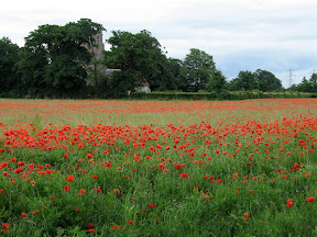
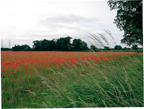
Further on was a field completely filled with poppies. Quite often in Suffolk the crop fields have quite a lot of poppies in them, but this was the fullest field I have ever seen. A farmer who used to own the field stopped and told us that this was the finest display he had ever known in 40 years. Apparently the field used to be regularly sprayed when sugar beet was grown there so they never came up. Then Jordans cereals wanted oats grown there, and the use of chemicals was restricted so the seed started to grow. Now the field has been set aside for a few years and this is the result.


The photo's really don't capture the full effect. The church is Blaxhall, so stop by if you are in the area soon.

After our exercise we rewarded ourselves with an Indian meal at The Bengal in Wickham Market.

Monday morning started out a bit wet so we were'nt sure what to do. We met up with R's old schoolfriend who was back in Suffolk for a few days and went to complete another geocache at Hemley. This involved looking round the church there to get information to put coordinates together where the actual cache container was hidden. This turned into a great walk along the River Deben.

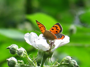
Next stop was Newbourne Springs nature reserve as the sun had now come out. We found a small clearing and had a picnic lunch there. The reserve was really quiet, we almost must have had it to ourselves. Apart from the loads of butterflys flitting about.


Moving on again we returned to R's parents house where the River Deben (much smaller here than it was at Hemley) runs past the end of their garden. We paddled along in a boat, watched by cows in the meadows alongside.


To cap the weekend off we went out for tea again, this time to The Seal pub in Woodbridge.

Shame to be back in work today! I'd much rather have continued our 'holiday at home'.